

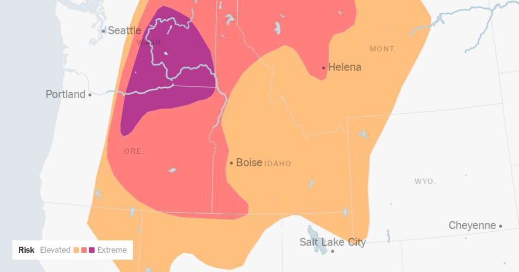
Powerful winds are expected to raise the risk of fire to critical levels across the northwestern United States on Saturday, and forecasters with the National Weather Service have issued their most urgent alert — “a particularly dangerous situation” red-flag warning — for large portions of eastern Washington and northeastern Oregon, where dozens of large fires are already burning.
“This is the first time the ‘particularly dangerous’ situation tag has been used with a red-flag warning in Oregon or Washington,” said Jon Bonk, a meteorologist for the federal Northwest Interagency Coordination Center, which manages fire coordination across the two states.
Red-flag warnings are commonly issued in this corner of the country in the summer, when dry vegetation, low humidity and gusty winds come together to create high fire risk.
Saturday’s alert carries the stronger, more rarely used warning language, and forecasters are concerned that existing wildfires and any new ones could grow terrifyingly quickly.
The phrase “a particularly dangerous situation” is meant to signal a worst-case threat and get people’s attention. “We want people to heed this warning in its fullest extent,” Mr. Bonk said.
The wildfire threat on Saturday extended into parts of Idaho and western Montana, with standard red-flag warnings in effect in some areas.
Wildfire risk increases in the Northwest between July and September. This summer was expected to be particularly active because of widespread drought.
The entire West, and particularly Oregon, got significantly less snow than usual during the winter, and the little that did fall melted away early amid record warmth.
In recent weeks large wildfires have chewed through desiccated forestland and forced communities to evacuate. The wildfire activity intensified after two separate outbreaks of lightning ignited dozens of wildfires in July, particularly in Central Oregon.
A timber fire is considered large when it reaches 100 acres, and a fire in grass gets the designation at 300 acres. On Saturday, there were 40 large fires burning across Oregon and Washington.
Among the largest is the Rowe Creek complex, a collection of fires that has scorched more than 300,000 acres in north-central Oregon. In Washington, just north of Coulee Dam, the Kaiser Canyon fire has burned more than 100,000 acres.
“Every fire that’s on the ground right now that’s showing any sort of heat to it has the potential to be affected by these winds,” Mr. Bonk said. “That’s why we want people to take this situation seriously.”
Since Jan. 1, there have been 58 large fires in the two states, burning more than 1.8 million acres.
By comparison, the five-year average at this point in the year is 49 large fires and 525,844 acres burned, according to Carol Connolly, a spokeswoman for the Northwest Interagency Coordination Center.
The heightened fire risk comes as an unseasonably strong storm was moving across the Canadian provinces of British Columbia and Alberta, with its southern edge swiping the Pacific Northwest and generating strong winds.
Widespread gusts of 35 to 50 miles per hour are expected, with gusts exceeding 50 m.p.h. in higher terrain in the eastern Pacific Northwest and northern Rocky Mountains. Mr. Bonk said eastern Washington will likely see the most severe winds.
“It’s one of those times when we expect our forecast to come to fruition, but it pains us as we don’t like to see the effects that come from this,” Mr. Bonk said.
The wildfire risk was expected to decrease slightly across eastern Washington and Oregon, northern Idaho and western Montana on Sunday, but the threat will remain and expand into central Montana and northwest Wyoming.