

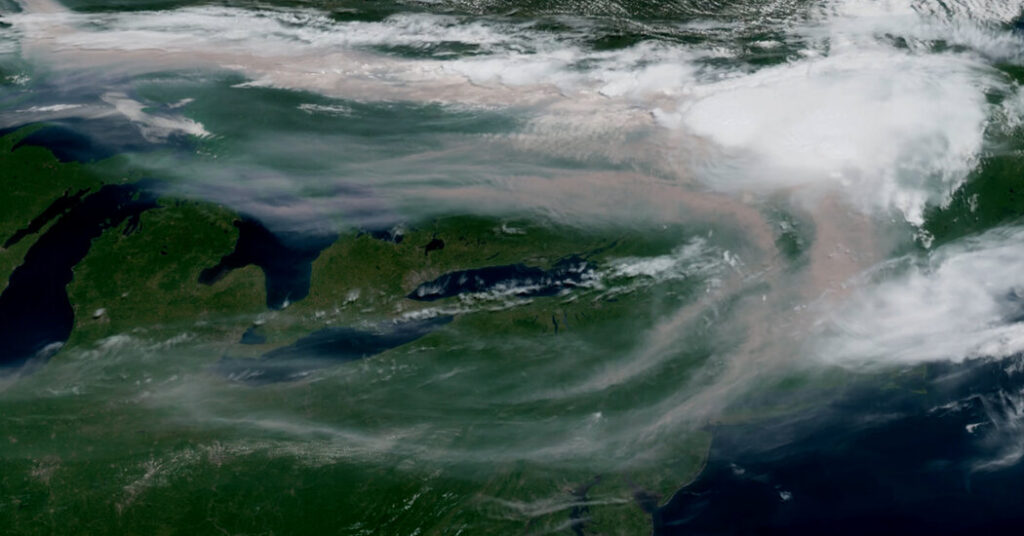
From the windows of office buildings across Manhattan, the blue sky turned hazy on Tuesday as wildfire smoke from Canada and the Great Lakes slipped across the Northeast, prompting alerts in some places about poor air quality.
The haze is expected to continue on Wednesday, and even to worsen in some places, as the same heat dome that is pushing temperatures close to 100 degrees across much of eastern Canada and the United States traps the smoke from faraway wildfires close to the ground.
In New York, city officials warned of “the possibility of deteriorating air quality” throughout the day Wednesday, but noted that even the most severe forecasts for did not approach the levels seen in 2023, when the Canadian wildfire smoke sent the city’s air quality index surging to dangerous levels. Still, they said, echoing the warnings of officials across the region, people with health conditions that make them sensitive to polluted air should take caution.
The heat dome, an area of high pressure in the atmosphere, was visible on satellite imagery on Tuesday as an area of clear sky over the middle of the country, where the surrounding air moves clockwise. On the ground, it manifests as a hot, humid and smoky stew that can make just stepping outdoors an unpleasant task.
Across much of the United States and southern Canada, weather officials have placed tens of millions of people under heat warnings, with high temperatures from the upper 90s to above 100 degrees expected in many places on Wednesday.
The National Weather Service said that nearly 100 million people from the Dakotas into New England would be under its “major” or “extreme” warning levels for dangerous heat. Environment Canada, the country’s weather service, said that, through Wednesday, southern Ontario would be under an orange alert, the second most severe in its three-tier system.
At least 17 wildfires spanning thousands of acres have forced evacuations across Minnesota, according to state officials, as flames spread through the state’s northeastern wilderness and into Canada.
Erik Evans, a spokesman for the Minnesota Department of Natural Resources, said that, as of 1 p.m. on Tuesday, the five largest fires combined were estimated to be scorching at least 30,000 acres of land. So far, fire officials have not been able to contain any of those fires, he said.
The fires prompted the U.S. Forest Service to close part of the Boundary Waters Canoe Area in Superior National Forest, a vast network of lakes and forest along the U.S.-Canadian border. The agency’s regional office said that three active fires were burning inside the Boundary Waters, and that a fourth had ignited on Monday just outside the protected area.
Two of the largest blazes — the Bear Trap and Thumb fires — have crossed the border into Canada, officials said.
“Fire management anticipate another very high fire danger day today with increased fire activity and fire growth,” the agency said.
Already this week, state authorities around the Great Lakes have issued alerts for poor air quality. In northeastern Minnesota, the state’s pollution control agency said that the air quality would likely remain “very unhealthy for everyone” through Thursday. Just across the border in southern Ontario, Environment Canada issued an orange-level alert on Tuesday for air quality and urged people to avoid spending time outside.
The heat dome has slowly been crossing North America over the past several days. It singed the Mountain West with record heat in places like Salt Lake City, where official readings surged to 109, two degrees above the previous high temperature recorded in 1960, 2002, 2021 and 2022.
Across the Northern Plains, the heat is setting consecutive days of daily records, and it could last through the end of the week. New York and other cities across the Northeast could set daily records on Wednesday, forecasters warned.
That is, unless the smoke gets worse. If the smoke thickens, which some forecast models suggest that it will, the temperatures may not climb as high because the smoke could filter the sunlight throughout the day, according to forecasters in the New York City weather office.
In addition to the heat and the smoke, there is a third potential danger from the heat dome: Along its northern edge are what meteorologists call “ridge-riding storms.” These intense thunderstorms form along the boundary of warm, moist air and cooler, dry air, and they can cause powerful winds, heavy rain, hail and even tornadoes.
At the start of this month, at the tail end of an earlier record-breaking heat wave, similar storms raced through rural Wisconsin, surprising boaters and leading to the deaths of three children.