

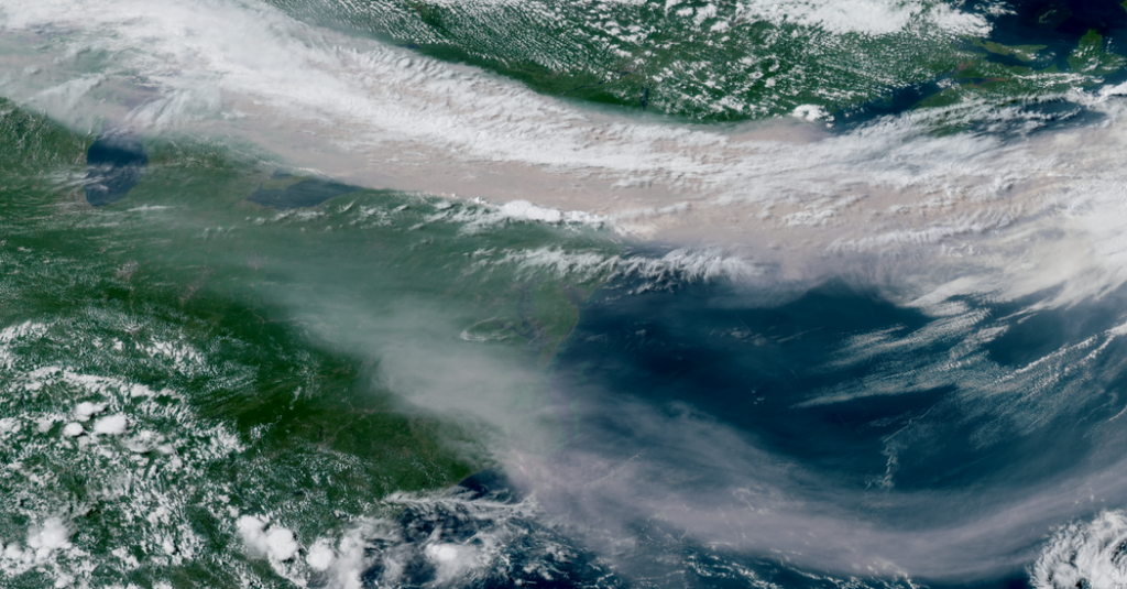
From space, the smoke looks a lot different from the apocalyptic orange and hazy scenes on Earth. But satellite images offer clues and crucial details of what is occurring below, and what is to come.
The thin ribbon of dense milky gray smoke draped across Canada’s border with the United States on Thursday gave meteorologists much-needed clues to help them forecast where the smoke would affect people.
Smoke forecasts are typically very difficult to get right. Experts first have to know where the smoke is coming from. The type of thick, dense plume that’s affected North America this week could have come from one large fire or many fires.
In this case, it came from many wildfires burning in Minnesota and across the border in Ontario. Strong winds at the earth’s surface helped to intensify these fires on Tuesday, spreading them quickly across dried vegetation on the ground. As more smoke poured high into the atmosphere, a river of air called the jet stream grabbed hold and carried it east.
The jet stream is like a river of really fast winds at a level in the atmosphere where planes often fly. It is responsible for a lot of the meandering weather patterns in North America, including atmospheric rivers, the transport of Arctic air in winter and the type of severe storms that spin up tornadoes and hail across the Midwest.
In this case, the really strong winds have taken the smoke and pushed it across the Great Lakes, through the Northeast and out over the Atlantic. The jet stream has kept it densely contained, blotting out the sun in places like Detroit and Toronto.
Let’s take a closer look at what satellites saw on Thursday.
New York: It was a lighter morning with an afternoon shift.
On Thursday morning, New York was on the southern edge of the thickest concentration of smoke. Though some smoke filtered down to the surface, and the air quality was unhealthy all morning, it wasn’t nearly as bad there as it was around the Great Lakes, closer to the actual fires.
New York would experience a shift later Thursday as more of the smoke made its way to the city, like water winding its way down to the end of a hose.
The Carolinas: Wednesday’s smoke is still a haze.
This is Wednesday’s smoke plume, having floated all the way down over the Carolinas by Thursday. It’s less concentrated here, so this part of the country is spared the thick, choking smoke that others are experiencing. But there is still a thin haze in some places on the ground.
The Great Lakes: The fires made their own weather.
You can see the fires actively burning in Minnesota, just to the northwest of Lake Michigan. They’re the gray puffs of smoke traveling up to join the larger clouds far up in the atmosphere.
At times, the fires on Tuesday were so intense, they created pyrocumulus clouds, which are like a thunderstorm and form from the hot rising smoke.
Eastern Canada: Some of the smoke is curling back around.
The smoke that hasn’t been caught back in the main weather pattern has raced along the jet stream and been sent back up into a storm system over eastern Canada. It’s being pulled out over the Atlantic Ocean, but is then wrapping back around that storm system and coming back toward Newfoundland in northeastern Canada. Nova Scotia is a rare clear spot amid all the smoke swirling to its south and north.
The Midwest: The heat dome is to blame for all of this.
This is the heat dome! It doesn’t look like much, does it?
This is the main factor in this miserable weather. The heat dome is the reason dry air and record-breaking temperatures have been trapped near the ground all week. It’s also why strong winds helped ignite fires in Minnesota and southern Ontario on Tuesday. And it is what has kept the jet stream stuck in its position for days.
But in the center of the heat dome, the sky is clear because air sinking to the ground from high up in the atmosphere is pushing everything else out of its way.
There is likely to be just a slight enough weather shift in the coming days to weaken the winds in the jet stream and slightly adjust its position.
Even if it still transports smoke, it most likely will be more dispersed, leading to better air quality in most places.